BEAUTIFUL LAYA-LINGSHI TREK ITINERARY IN BHUTAN
(Duration: 13 Days) This trek is sometimes referred to as the Laya Trek and is one of the finest and the most beautiful trek in Bhutan. More info...
Beautiful Laya-Lingshi Trek
Duration: 17 Days/16 Nights.
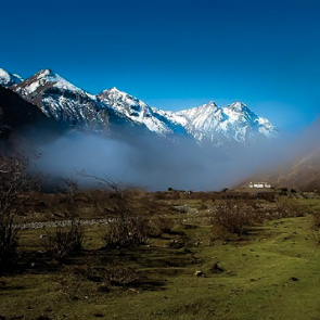
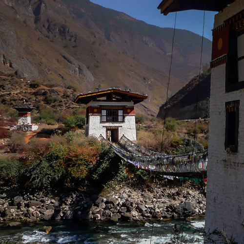
Grade= Moderate. Time=13 Days. Distance=186.5kms. Altitude Gain=5,200m. Altitude Loss=7,010m. This trek is sometimes referred to as the Laya Trek and is one of the finest and the most beautiful trek in Bhutan. The route starts from Paro-Shana-and continues onwards to Jumolhari camp. It then goes via Lingshi to Laya and exists at Gasa. Making a halt at the Jumolhari Basecamp and another halt at Laya village. The trek offers great views of the snow-capped mountains like the Mt. Jumolhari(7,314m), Mt. Tsherimgang( 6,526m), Mt. Jitchu Drakey(6,850m), Mt. Gangchenta/Great Tiger Mountain(6,840m), Mt. Masa Gang(7,200m), Tsenda Gang(7,000m), Kangbum(6,500m). The trek ends with a night halt at the Hot springs of Gasa.
Trekking Habits
On a typical trek day, we will be woken at 6:00 am, by a member of a camp crew bringing bed tea (in your tent), followed shortly by a bowl of hot washing water. By 7:00 am, when breakfast is ready, we will have packed ready for the day’s activity (day pack and main luggage). We leave with our guide just before the camp crew at 8:00 am and spent the rest of the day at an unhurried but steady pace. We stop for about an hour for lunch, which will be carried by a camp crew and continue for our next campsite. The crew will break down the tents, load the horses, overtake us and have the camp ready for our arrival. A hot drink will be ready when we arrive, followed by wash water and our evening meal. After dinner, we will discuss for the following day with our guide before retiring to bed. This will sound familiar to anyone who has trekked in Nepal, the main difference being that camp crew is smaller in Bhutan and there are no tea houses along the way.
*Note: Use designated campsites only approved by the Tourism Council of Bhutan. No campfires and cooking fires at the campsites. Usage of LPG (liquid petroleum gas) is mandatory for cooking. Pack out solid waste (pack it in and pack it out), should not bring out flora and fauna products, respect the nature and the culture of the area. Most trekking routes are in the National Parks and Reserves.
Fitness
It is essential that participants undertake regular walking and hiking in the months leading up to the start of the Tour so that you can enjoy to the full what the trip offers. The itinerary gives an indication of distance and elevations involved. Previous experience of multi-day trekking as well as of extended periods of camping over 3,000m is preferable.
Acclimatization
Every effort has been made to allow gradual acclimatization to altitude, but this is a factor which is unpredictable for anyone. Many folks have their own ideas of how to combat the effects of altitude and we always carry Diamox (Acetazolamide) with us and use it if we feel the need. If you plan to use such a drug for the first time, visit your doctor well in advance of the trip and ensure that you have a trail at home so that you understand what the effects is on you before administering it at height. If anyone were to suffer bad reaction to altitude and need to lose height the route of the trek allows us to do so at certain points of the trek.
Weather
At valley floor conditions are likely to be humid, even hot on sunny days, becoming less so as we rise towards the tree line. We all appreciate that mountain weather is unpredictable, and difficult to forecast in areas we visit only rarely but our experience is that one should expect some rain at some point on most days, that snow may fall on high passes but not lie long, and that sunny, clear periods, usually from dawn into the mornings, when encountered, afford stunning views, memories and pictures.
Day1. Arrive in Paro, Bhutan
The flight into Bhutan takes you over the Himalayas, offering glimpses of the highest glacial peaks. On arrival at the airport, after immigration and custom formalities, your local guide-for the whole trip, will receive you and transfer to the hotel. After check-in and refreshments, visit the National Museum housed in a 17th century watch tower which will serve as a great introduction to Bhutan before you delve deeper into the country.
Visit the Rinpung Dzong, the medieval provincial capital fortress the watch tower protected for three hundred years of civil strife.
O/N at Hotel in Paro. Elevation: 2,300m.
Day2. Paro Halt, Hike to Tiger’s Nest (Taktsang)
After breakfast, before the sun is too strong start the hike up to the Tiger’s Nest, perched 900m high above the valley floor. This temple is one of the most sacred pilgrimage sites in the world for Buddhist practitioners, many Buddhist masters have made their way into Bhutan to visit, meditate, and to offer their prayers to the great Guru. Guru Rinpoche (Padmasambhava) is said to have flown to this place riding on the back of a tigress from Khenpajong in Eastern Bhutan. The hike covers a little over 6kms and it takes 5 hours to go up, visit the shrines inside and to come down.
Then visit the ruins of Drukgyal Dzong, in the northern corner of the valley. On the way back, visit the Kyichu lhakhang, a 7th century temple, founded by the Tibetan King Songtsen Gampo.
O/N at Hotel in Paro. Elevation: 2,300m.
Day3. Paro-Shana-Thangthangkha (22kms/13.6miles, 8-9hrs, altitude gain=2,250ft/685m, altitude loss=0ft/0m).
Start hiking following the river on the right, crossing small tributaries for 2-2.5hrs till you come to Shing Karap. Another 20 minutes is the junction, the right trail leads to Thangdo Zampa, which is the lunch spot. Another 3hrs through beautiful forest consisting of birch, fir, larch, maple and rhododendron with small ups and downs will lead to Sendey Zampa(3,560m). Half an hour from here is the camp of Thangthangkha in a big meadow, the round tip of the Jumolhari is visible from the camp.
Camp altitude 3,575m.
Day4. Thangthangkha-Jangothang (17kms/13.5miles, 4-6hrs, altitude gain=1,530ft/469m, altitude loss=0ft/0m).
It’s an hour of walk through the forest following the river upstream, crossing a military camp at 3,730m. Then the trail passes a meadow with a chorten and then Tikithang and Dangochang before the campsite at Jangothang.
Camp altitude 4,044m/13,260ft.
Day5. Jangothang Halt (Acclimatization Day).
Most people will feel the effects of ascending 1,800m in just two days, so a rest day at Jumolhari Base camp will help with acclimatization. There are some good day hikes from the camp, and it is important to hike today so that you will acclimatize. Follow the standard rule: trek high, sleep low.
Hike to the Twin Lakes Tsho Phu 14,270ft/4350m, which are full of trout (2hrs to the lakes, 1.5hrs back to camp). From the lakes there is a spectacular views of the Jumolhari and jitchu drakey.
The most challenging day hike is up the steep, grassy ridge located next to the camp to the north. It takes 3-4hrs to reach the final rocky summit (15,975ft/4,870m), the views get better and better, Jitchu Drakey ( 22,470ft/6,850m), Jumolhari (23,995ft/7,315m). The last part of the rocky summit can be tricky due to loose rocks and strong winds, bring a wind proof jacket, gloves and hat.
Day6. Jangothang-Lingshi (21kms//845m, 13miles, 6-7hrs, altitude gain=2,780ft/845m, altitude loss=2,890ft/880m).
The walk is gradual ascend till the end of the village, after crossing the bridge over the Pa chhu it climbs steeply for some 100 mtrs to a ridge, where you get a clear view of last night’s campsite. Still climbing high to reach the Nyile La Pass (16,040ft/4,890m), the first pass of this trek. Today’s trek will test your level of acclimatization, if you are having problems this is the time to turn back; once you have crossed over to Lingshi you can only get out by crossing high passes.
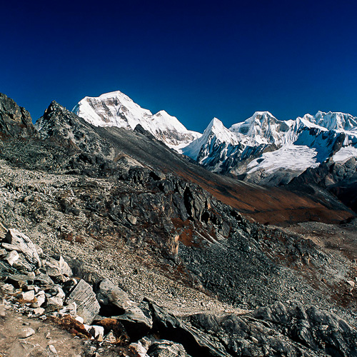
The pass offers a great view towards the east-northeast into the trekking area covered over the next couple of days. Mount Tsherim Kang/Takayphu, 21,405ft/6,526m dominates the view towards the north. Great Tiger Mountain is the main mountain to be seen in the east.
After the pass, the trail descends down to a stream, after crossing it the trail is easy, flat and good till you see Lingshi Dzong, then it drops down on a steep slope to the campsite at Chazithang.
Camp altitude 13,150ft/4,010m.
Day7. Lingshi-Chebisa (16kms/10miles, 4hrs, Altitude gain/loss=0m).
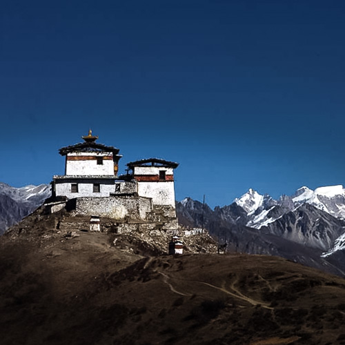
From the camp the trail climbs after crossing the river to a ridge at 4,100m/13,450ft, from here you can climb up the ridge to the Dzong or to the ridge left of the Dzong for pictures. Just below the Dzong is the first village of Lingshi, along with the school. After the school the the trail is flat till the ridge before Gangyul village. Explore the village here and visit the Ja Goed Dzong, built by Phajo Drugom Zhigpo. Another hour walk leads to Chebisa village where your campsite for the day.
Cam altitude 13,090ft/3,990m.
Day8. Chebisa-Shakeypasa (14.5kms/9miles, 5hrs, Altitude gain=1,470ft/450m, Altitude loss=1,440ft/440m).
After the village a stiff, steep climb of 450m up a grassy slope leads to Gogu La pass (14,560ft/4440m. You may encounter with the Himalayan Blue Sheep and the Bearded Vultures(perhaps in connection with sky burial).
After the pass the trail drops to Chumiten, attractive lunch spot. Another hour of gradual downhill brings you to the camp of Shakeypasa.
Camp altitude 13,120ft/4,000m.
Day9. Shakeypasa-Tsari Jathang/Tsheri Yango (16kms/10miles, 7-8hrs, Altitude gain=3,100ft/945m, Altitude loss=2,575ft/785m).
It’s a steep climb of 3hrs to the Jharila Pass(15,695ft/4785m), the pass provides great views of Jumolhari 1 and 2, Tsherimgang, Gangchenta (Great Tiger Mountain) and also the pass for tomorrow, Shinche La Pass (16,400ft/5,000m). After the pass the trail descends on a steep slope to Tsari Jathang (4,000m/13,120ft). It’s another 40minutes of climb to the camp at Tseri Yango.
Camp altitude 4,160m.
Day10. Tseri Yango-Limithang (14kms/8.5miles, 7-8hrs, altitude gain=2,755ft/840m, altitude loss=2,755ft/840m).
Leaving the camp, the trail climbs a steep zigzag trail leading to a platform with some prayer flags at 4,400m. From here a large glacier valley opens up leading towards the east and finally to today’s pass. Shinche La Pass (16,400ft,5,000m), Gangchenta(Great Tiger Mountain) is visible to the northeast, Jejegangphu and Masgang(23,600ft/7,194m) and the Black Mountain Range(15,145ft/4,617m) in the east-south direction.
The trail descends on the other side of the pass with rocks and steep parts bringing you to an enormous moraine and glacial lake below the Tiger Mountain. Another hour downhill will bring you to an opening in the woods, which is the Limithang campsite.
Camp altitude 13,645ft/4,160m.
Day11. Limithang-Laya (9kms/5,5miles, 4hrs, altitude gain=nil, altitude loss=1,180ft/360m).
Today is an easy day of gradual downhill to Laya Gewog (county), though there are some small climbs and drops but no elevation is gained. Laya gewog consists of six villages namely; Toko, Pashi, Neilo, Lubcha, Tongra, Lungo. Tsenda Gang(23,160ft/7,200m), dominates the Laya village. Laya Gewog is still part of Jigme Dorji National Park.
Camp altitude 12,465ft/3,800m.
Day12. Laya Halt.
Explore the village and visit the school, or hike up to the lakes of Ongme Tsho and Kharkil Tsho.
Day13. Laya-Koina (16kms/10miles, 6-7hrs, altitude gain=0m, altitude loss=1,837ft/560m).
After the village of Laya the trail drops down to Zamto Nangi Chhu and Togtserkhagi Chhu leading to the army camp at Tashi Makhang. Continue on following the Mo-Chhu on the left till Tongshingna where you cross a cantilever bridge and then climb up a ridge 200m and drop down again to level with the river. Another 45minutes of gradual downhill will bring you to a final climb of the day to Kohi Laptsa (3,380m), and descend to Koina campsite.
Camp altitude 10,627ft/3,240m.
Day14. Koina-Gasa (12kms/7.4miles, 6hrs, altitude gain=2,165ft/660m, altitude loss=5,510ft/1,680m).
It’s a good 1.5hrs of climb to get to Chamsa, an optional campsite and another 1.5hrs to the Barila Pass(12,320ft/6,500m). Then descending through the broadleaved forest for an hour or so you can see the Gasa town peeking through the trees with Kangbum (21,320ft/6,500m) in the background.
Visit to the Gasa dzong is an option or continue downhill to the Hot Springs and relax, a hot shower well deserved.
Camp altitude 7,282ft/2,200m.
That brings you to the end of the Beautiful Laya-Lingshi Trek.
Day15. Gasa to Punakha (75kms, 4-5 hours drive).
After breakfast, drive to Punakha, it takes 4-5 hours to get to Punakha.
Visit the mighty Punakha Dzong, situated at the confluence of the Pho Chhu (male) and Mo Chhu (female) rivers.
O/N at Hotel in Punakha. Elevation: 1,280m.
Day16. Punakha-Thimphu.
· Hike to Chimed Lhakhang, a popular destination for locals and tourist alike, known for its fertility.
Then drive over the Dochula pass 3,150m, into Thimphu, after lunch;
· Visit the National Memorial Chorten, built in memory of the Third King Jigme Dorji Wangchuck, lovingly known as The Father of Modern Bhutan.
· Giant Buddha Statue at Kuenselphodrang, 169ft/51m.
· Mini Zoo, which showcases the Nation Animal, the Takin along with some Deer and Mountain goats.
· In the evening, visit the Tashicho Dzong.
O/N at Hotel in Thimphu. Elevation: 2,320m.
Day17. Departure.
After an early breakfast, drive to the Paro International Airport for your onward destination.
MOUNTAIN BIKING AND CULTURE TOUR ITINERARY IN BHUTAN
(Duration: 13 Days) This Tour is a combination of Culture and Mountain Biking, specially designed for the one’s seeking adventures. More info...
This Tour is a combination of Culture and Mountain Biking, specially designed for the one’s seeking adventures. The tour will take you over the mountain passes deep into the Central Part of the country, visiting Religious Buddhist sites, engaging in local activities, biking the rough terrain of Bhutan.
Day01. Arrive in Paro and transfer to Thimphu (58kms, 2hrs drive).
After immigration and custom formalities, our representative and your guide for the entire trip will receive you and escort you to a restaurant for refreshment. Then drive to Thimphu(Capital of Bhutan).
- En route visit the Tamchogang Lhakhang (15th century temple), with a Iron-Chain Suspension Bridge, one of the Traditional Bridges in Bhutan.
- Next stop at the Chuzom, the confluence of the Wang Chhu and the Pa Chhu, to take a look at Three Styles of Stupas, The Tibetan, The Nepalese and the Bhutanese styles.
Then continue the drive to the Thimphu city, the biggest city in the country with a population of 100,000.
- Time permitting visit the Semtokha Dzong, 17th century fortress turned into a Monastic School.
O/N at Hotel.
Day02. Thimphu Sightseeing.
- Visit the National Memorial Chorten, (stupa, built in memory of the Third king).
- Kuenselphodrang, for the giant Buddha Dordenma Statue, (169ft,51m).
- Changangkha Lhakhang, one of the oldest temple in the Thimphu Valley.
- Takin Preserve, which showcases the National Animal, the Takin along with few species of Deer and Mountain goats.
- After lunch, get on our bikes and ride to Dodena (Base of Cheri Goemba) 16kms. If you have the stamina and time permitting hike to Cheri Goemba. And bike back to the city. This biking will help you as a training session for the rest of your biking tours.
O/N at Hotel.
Day03. Thimphu-Punakha (79kms, 3hrs driving time).
Today we drive to Dochula pass (3,150m), weather permitting, there are great views of the Himalayas, including the Highest Unclimbed Peak, Gangkar Puensum (7,560m).Visit the Druk Wangyal Lhakhang, which has some of the most intricate and finest wood and stone works in the country. After pictures, we ride our bikes down the other side of the pass into the Punakha district to Lobesa where we stop for lunch.
- After lunch, a short hike to Chimed Lhakhang, a popular destination for fertility for locals and tourist alike.
- Ride to the Hotel, which is another 10kms approximately. Relax for the evening.
O/N at Hotel.
Day04. Punakha Sightseeing.
- Early breakfast, hike to Khamsum Yuelly Namgyal Chorten.
- Drive back to Punakha and visit the magnificent Pungthang Dechen Phodrang Dzong.
- After lunch, get on your bikes and ride the Talo road to the monastery and back to hotel or take the feeder/farmroad to samdingkha and back.
O/N at Hotel.
Day05. Punakha-Phobjikha(127kms, 3-4hrs).
In the morning drive to Phobjikha,
- Visit the Gangtey Sangnacholing Monastery, the only Nyingmapa monastery to the western part of the country.
- Either hike the Nature Trail (4.1kms, 1hr), or bike your way down to Phobjikha valley and continue to the furthest village and to the Hotel.
O/N at Hotel.
Day06. Phobjikha-Bumthang(130kms,4 hrs drive).
Drive to Pelela Pass (3,300m), after the pass the road goes downhill to Chendebji and into Trongsa, so you can get on your bike and ride till Trongsa.
- After lunch, visit the Trongsa Museum/ the Dzong. And continue your drive to Bumthang over the Yotongla Pass3,400m).
- Stop at the Weaving place at Chumey, this area is well known for its Yathra products, textiles woven out of sheep and yak wool.
O/N at Hotel.
Day07. Bumthang Sightseeing.
- Visit the Jampa Lhakhang, 7th century temple, founded by the Great Tibetan King Songtsen Gampo.
- Kurje Lhakhang, sacred temple where Guru Padmasambhava meditated in a Rock Cave in the 8th century and freed King Sindhu Raja from the grip of Shelging Karpo, the local deity.
- Hike to the Tamshing Lhakhang, which is on the other side of the river.
- In the afternoon, drive to the Farmhouse and practice Archery, the national sport of Bhutan and engage in preparing for the Hot Stone Bath.
O/N at Hotel.
Day08. Bumthang-Tang (50kms, 2hrs drive).
- Visit the Museum at Ugyencholing.
- After lunch bike to Mebar Tsho, the Burning/Flaming Lake, where Terton Pema Lingpa, the great treasure revealer, discovered the religious treasures. Bike back to the Hotel.
O/N at Hotel.
Day09. Bumthang-Trongsa (68kms, 2hrs drive).
Bike to Trongsa after visiting the Wangdicholing Palace in Bumthang, stop at Chumey Nature Resort for lunch, then continue on your bike to Trongsa.
O/N at Hotel.
Day10. Trongsa-Thimphu (200kms, 8hrs drive).
Today we will be back tracking to Thimphu, it’s a driving day than a tour.
Day11. Thimphu-Paro(58kms, 2hrs drive).
- After breakfast, bike to Paro and check into the Hotel, after refreshing visit the National Museum.
- Visit the dzong, which houses the Administrative Centre and the Monastic Community of Paro province.
O/N at Hotel.
Day12. Paro sightseeing.
- Hike to Tiger’s Nest (Taktsang), this hike takes 4-5hrs both ways and visiting the temple.
- After the hike, visit the ruins of Drugyal Dzong and Kyichu Lhakhang, one of the oldest Buddhist temple in the country.
- In the evening, stroll around the town on your own or look for Souvenirs.
- Cultural Program by a local band.
SNOWMAN TREK ITINERARY IN BHUTAN
(Duration: 25 Days) Known to be the “Worlds Toughest Trek”. The combination of distance, altitude, remoteness and weather makes this a tough journey. More info...
Snowman Trek 30Days/29Nights

Snowman Trek 30Days/29Nights
Trek info: Duration: 25 Days 24 Nights. Grade: Strenuous. Maximum Elevation: 5320m.
Known to be the “World’s Toughest Trek”. The combination of distance, altitude, remoteness and weather makes this a tough journey. Fewer than half the people who attempt this trek actually finish it, either because of problems with altitude or heavy snowfall on the high passes. This trek goes through some of the remote villages of Laya and Lunana, providing great views of the snow-capped mountains. Trekkers have the opportunity to spot the Takins, Blue Sheep, Himalayan Black Bear, Marmots and many yaks and yak herders. This trip is one of the longest combined with the “World’s toughest Trek”, lasting 30Days/29Nights.
Trekking habits
On a typical trek day, we will be woken up at 6:00 am, by a member of the camp crew bringing a bed tea (in your tent), followed shortly by a bowl of hot washing water. By 7:00 am, when breakfast is ready, we will have packed ready for the day’s activity (day pack and main luggage). We leave with our guide just before the camp crew at 8:00 am and spent the rest of the day at an unhurried but steady pace. We stop for about an hour for lunch, which will be carried by a camp crew and continue to our next campsite. The crew will break down the tents, load the horses, overtake us and have the new camp ready for our arrival. A hot drink will be ready when we arrive, followed by wash water and our evening meal. After dinner, we discuss for the following day with our guide before retiring to our bed. This will sound familiar to anyone who has trekked in Nepal, the main difference being that camp crew is much smaller and there are no tea houses along the way.
*Note: Use designated campsite only approved by the Tourism Council of Bhutan. No campfires and cooking fires at the campsites. Usage of LPG (liquid petroleum gas) is mandatory for cooking. Pack out solid waste (pack it in and pack it out), should not bring out flora and fauna products, respect the nature and culture of the area. Most trekking routes are in the National Parks and Reserves.
Fitness
It is essential that participants undertake regular walking and hiking in the months leading up to start of the Tour so that you can enjoy up to the full what the trek offers. The itinerary gives an indication of distances and elevations involved. Previous experience of multi-day trekking as well as extended periods of camping in mountains over 3,000mts is preferable.
Acclimatization
Every effort has been made to allow gradual acclimatization to altitude, but this is a factor unpredictable for anyone, even those who have performed well on past trips. On this trip we camp over 4,700m and sometimes at 5,000m so this must be borne in mind. Many folk have their own ideas how to combat the effects of altitude and we always carry Diamox (Acetazolamide) with us and use it if we feel the need.
If you plan to use such a drug for the first time, visit your doctor well in advance of the trip and ensure that you have a trail at home so that you understand what the effects is on you before administering at height. If anyone where to suffer a bad reaction to altitude and need to lose height the route of the trek allows us to do so at certain points of the trek.
Weather
At valley floor conditions are likely to be humid, even hot on sunny days, becoming less so as we rise towards the tree line. We all appreciate that mountain weather is unpredictable, and difficult to forecast in areas we visit only rarely but our experience is that one should experience rain at some point on most days, that snow may fall on high passes but not lie long, and that sunny, clear periods, usually from dawn into the mornings, when encountered, afford stunning views, memories and pictures.
Day1: Arrive in Bhutan
The flight into Bhutan takes you over the Himalayas, offering glimpse of the highest glacial peaks. On arrival at the airport, after immigration and custom formalities, your local guide-for the whole trip, will receive and transfer you to the hotel. After check-in and refreshment/lunch, start exploring Paro, the sites include: The National Museum, housed in a 17th century watch tower which will serve as a great introduction before you delve deeper into the country. Then visit the Rinpung Dzong the medieval provincial capital fortress the watch tower protected for three hundred years of civil strife. Later take a short walk down to Nyemi Zampa (Cantilever bridge) that connects the valley to the dzong.
O/N at Hotel in Paro. Elevation: 2,300m.
Day2: Paro Halt
After breakfast before the sun is to strong, hike to taktsang (literally translated as Tiger’s Nest). Built in 1600’s, this incredible monastery/temple clings to a sheer rock cliff that plunges 900mts into the valley below. The history states that Guru Rinpoche, the Tantric mystic who brought Buddhism to Bhutan, landed here on the back of a flying tigress. Looking at the monastery/temple flying tigress doesn’t seem so impossible after all. The trail to the monastery/temple climbs through rhododendron and pine forest, lichens overhanging from the trees above notifies that you are walking amidst pristine forest, surrounded with clean, fresh air without any pollution. It takes 5 hours in total to hike and visit the shrines inside.
Visit the ruins of Drukgyal dzong, in the northern corner of the valley overlooking the village of Drukgyal, founded by Zhabdrung in the 17th century, which was lost to a fire in 1965.
On the way back visit the kyichu Lhakhang, founded by the Tibetan King, Songtsen Gampo to overcome a giant ogress whowais lying over the Himalayas trying to stop the spread of Buddhism. Legends has it that the King built 108 of these temples throughout the Himalayas.
O/n at Hotel in Paro. Elevation: 2,300m.
Day3: Drukgyal to Shana. 15kms, 5-6 hours, 360m ascent, 80m descent.
Drive to Drukgyal, the starting point of the trek. Visit the ruins of the Drukgyal Dzong, built as a monument of victory over the Tibetians invaders in the 17th century. From here you can see the crown of Jumolhari 7314m, the base of which we will be making camp in few days. The trail follows Paro river gently uphill through a narrowing valley of paddy fields. You will pass many traditional farmhouses along the way. The campsite is in a meadow past an army outpost. Camp altitude 2800m. Overnight in Camp/Tent.
Day4: Shana to Thangthangkha. 22kms,7-8 hours, 770m ascent, 10m descent.
Continue uphill following the river and through the valley, which narrows and closes in after some distance. The trail then winds up and down along the drainage. Most of the trail actually is uphill after the initial climb. The campsite is located in a meadow with stone shelter. Camp altitude 3400m. Overnight in Camp/Tent.
Day5: Thangthangkha to Jangothang. 19kms, 5-6 hours, 480m ascent.
Gradual climb as the vegetation turns rapidly alpine, past an army outpost until the landscape opens up into wide valley. The view around is surrounded by high ridges and the snow-capped mountains all the way to Jangothang. You will also come across yaks and yak herders camps. Camp altitude 4040m. Overnight in Camp/Tent.
Day6: Jangothang Halt (Basecamp).
Rest or explore the valley. There are many options for exploring including climbing the ridge behind the camp for better view of Jumolhari and Jichu Drakey or walk to the glacial basin of Jumolhari or to the glacial lakes of Tshophu. A stop here does good for acclimatization since the route here on goes higher.
Day7: Jangothang to Lingshi. 18kms, 6-7 hours, 840m ascent, 870m descent.
After about 15 minutes from the camp the trail climbs rapidly for about half an hour and then becomes a gradual ascend to the Nyelila pass 4870m. You might see herds of blue sheep grazing on the slopes of the mountains. From the pass you will have spectacular views of Mt. Jumolhari, Jitchu Drakey and Tsherim Gang, all of them rising above 7000m. On the way down to the camp you will pass by some of the yak herders tent, made from yak wool where the herders take shelter while on the move to various pastures for their yaks. Before you drop down to the campsite, Lingshi Dzong comes into view overlooking the village and the route to Laya. Camp at Chazithang (4,010m). Overnight at Camp/Tent.
Day8: Lingshi to Chebisa. 10kms, 4-5 hours, 280m ascent, 410m descent.
It is the shortest walking day, and you can really take it easy. Shortly after starting you will come to a chorten below the Lingshi Dzong. Here, you have a choice of staying on the main trail or taking a diversion up to the Lingshi Dzong (4220m), which sits right atop a ridge. After Lingshi Dzong you will be passing the villages of Lingshi and Goyul. In Goyul, the stone houses are clustered together to a small compact village that is unusual in Bhutan where village houses are normally scattered.The campsite of Chebisa has a beautiful waterfall behind the village. Camp altitude 3880m. Overnight at Camp/Tent.
Day9: Chebisa to Shakeypasa to Shomuthang. 17kms, 6-7 hours, 890m ascent, 540m descent.
The trail climbs up to the Gobu La pass, another chance to see herds of blue sheep. After the pass you descend to the valley into Shakeypasa 3980m, where a helipad had been established. Climb from here till you reach the campsite of Shomuthang above a stream, which is a tributary of the Mo Chhu. Camp altitude 4220m. Overnight at Camp/Tent.
Day10: Shomuthang to Robluthang. 18kms, 6-7 hours, 700m ascent, 760m descent.
It is a two hour climb to the Jhari la pass 4750m, from here you catch the first sight of Shinche la, the pass you will cross tomorrow. Gangchenta, The Great Tiger Mountain 6840m, can be seen to the north. Tsherim Gang and the peak of Jumolhari can also be seen on a clear day. From here the trail drops down to Tshari Jathang, herds of Takins, Bhutan’s National Animal, migrate to this valley in summer and remain here for about four months. Climb up a little to get to the campsite of Robluthang 4160m. Camp altitude: 4,160m. Overnight at Camp/Tent.
Day11: Robluthang to Limithang. 19kms, 6-7 hours, 850m ascent, 870m descent.
Climb gradually up to the Shinche la pass 5200m, the highest pass on the trek. After the pass, descend down to a little stone house where a few Laya women dressed in typical costume with long pointed bamboo hats on their heads live. On the other side you will see an impressive terminal moraine and a glacial lake at the foot of the valley. Below the moraine, cross the Kango Chu and soon reach the Limithang campsite. The peak of Gangchenta towers over the campsite. Camp altitude 4140m. Overnight at Camp/Tent.
Day12: Limithang to Laya. 10kms, 4-5 hours, 60m ascent, 340m descent.
The trail goes downhill along a narrow winding river valley. After sometime, the trail passes through deep forest and finally enters the west side of the Laya village. In the centre of the village is a school and a basic health unit with telephone connections. The campsite is below the school. Camp altitude 3840m. Overnight at camp/tent.
Day13: Laya Halt.
This day is to explore and learn about the tribal community of the remote Himalayan region of Laya (very unique to the country and the world). Visit the community school, hike to the village of Lungu if you still have enough energy after ten days of rigorous trek.
Day14: Laya to Rodophu. 19kms, 6-7 hours, 1030m ascent, 70m descent.
After the village the trail drops to the river and follows the river left till the army out-post. Then the trail leads gradually downhill to Lunana trail junction, taking left the trail leads to a ridge with good views of the rivers below, Mo Chhu and the Rhodo Chhu. The forest on this side has been burnt down, the trail continues to climb gradually up the Rhodo Chhu valley through rhododendron shrubs above the tree line. At the top of the large rock slide there is a view of the broad glacier valley and a massive glacier on Tsenda Gang 7100m, towering overhead. Overnight in camp/tent.
Day15: Rhodophu to Narethang. 17kms, 6-7 hours, 720m ascent.
The path crosses the wooden bridge and follows the river upstream through rhododendron shrubs for 20 minutes before turning right up the hill to Tshomo La 4900m, providing views towards the Tibetian border and Jumolhari. From here the trail becomes more gradual but still ascending to the camp to Narethang 4900m. Overnight in camp/tent.
Day16: Narethang to Tarina. 18kms, 5-6 hours, 270m ascent, 1200m descent.
From the camp the trail ascends for an hour up to Gangla Karchung la 51200m, Mountain views are great from here, Kangbum 6526m, Tsenda Gang 7300m, Teri Gang 7300m, and Jejkangphu 7100m can be seen. The Path descends along a large moraine to the edge of a near-vertical wall, views from the ledge are breathtaking- among the best along the entire trek. The trail drops steeply from here to the Tarina Valley, which provides lots of campsites just by the river. Camp altitude 3,938m. Overnight in camp/tent.
Day 17: Tarina to Woche. 17kms, 6-7 hours, 275m ascent, 330m descent.
The trail leads through conifer forest down the Tang Chhu on the river left, passing some impressive waterfalls cascading down both sides of the valley. The trail climbs gently out of the valley past several landslides and eventually climbs steeply to the northeast into the high side valley of Woche. Woche is a small settlement of 5 houses at 3940m and is the first village in the Lunana region. Overnight in camp/tent.
Day18: Woche to Lhedi. 17kms, 6-7 hours, 980m ascent, 950m descent.
The path to Lhedi begins below the camp and climbs the Woche valley, crossing a stream and climbing over a moraine before descending to a wooden bridge across the Woche Chhu. It then climbs to the Keche La 4650m. From the pass there are excellent views of the surrounding mountains, including Jejekangphu Gang’s triple peak. Descend down to Thega village 4050m, and then the trail gradually follows the Pho Chhu bank up to Lhedi 3700m. There is a school and a BHU, camp just beyond the school. Overnight in camp/tent.
Day19: Lhedi to Thanza. 17kms, 6-7 hours, 400m ascent.
The trail follows the north bank of the Pho Chhu past several small farms into Chozo village 4090m, There is a small dzong in the village, and to the right is a ridge which offers good views of the Table Mountain. The trail to Thanza continues along the left bank of the Pho Chhu through a flooded area full of sand, which will take another two hours to the camp. Camp altitude 4100m. Overnight in camp/tent.
Day20: Thanza Halt.
This day is taken as a rest day for the trekkers and arranging the pack animals for the next day, here the pack animals of Laya leave us and go back so we switch pack animals with the Lunaps, the people of Lunana.
Day21: Thanza to Danji. 8kms, 3-4 hours, 80m ascent.
The route climbs from Toench to a large boulder on the hill south of the village, from here there are excellent views of the villages below and the surrounding mountains. The path then turns east up a side valley another few hours you are at Danji camp 4180m. Overnight in camp/tent.
Day22: Danji to Tshochena. 12 kms, 5-6 hours, 490m ascent, 240m descent.
There is a trail junction just after the camp, the trail up the valley leads to the Gangkar Puensum base camp and to Bumthang. The path to the right crosses a creek and leads up a rocky side valley. It is a long climb to the Jaze la pass 5150m, which offers spectacular views of mountains in all directions. The path then descends down to Tshochena passing small lakes to the camp at 4900m. Overnight in camp/tent.
Day23: Tshochena to Jichu Dramo. 14kms, 4-5 hours, 230m ascent, 140m descent.
The trail follows the shore of the blue-green lake before climbing to a ridge at 5100m, from the ridge there is a 360-degree panorama view of the snowy peaks, the microwave tower and the road at Dochula are just visible in the distance. The path makes several ups and downs over small rounded hills before coming to the Loju La pass 5140m. There are many trails at the pass the correct path leads you across a small saddle at 5100m into a wide glacier valley. Then the trail gradually descends to the camp at Jichu Dramo 5050m. Overnight in camp/tent.
Day24: Jichu Dramo to Chukarpo. 18kms, 5-6 hours, 320m ascent, 730m descent.
After leaving camp the trail climbs through a moraine to Rinchen Zoe La 5320m, which divides the Pho Chhu and the Mangde Chhu drainages. The Rinchen Zoe peak towers above the pass 5650m and the major Himalayas stretch along the northern horizon. From the pass the trail descends to Metachuta and further down to Chukarpo 4600m. Overnight in camp/tent.
Day25: Chukarpo to Thampe Tsho. 18kms, 400m ascent, 640m descent.
The trail continues to descend along the right bank of the river until it reaches Gala Pang Chhu 4010m. From here the trail begins to climb through junipers and silver firs towards Thampe Tsho passing 4300m. Overnight in camp/tent.
Day26: Thampe Tsho to Maurothang. 14kms, 5 hours, 280m ascent, 1020m descent.
The trail climbs steeply to Thampe La at 4600m. The path descends to Omtey Tsho, sacred lake where Pema Lingpa found a number of treasures, then drops down 100m to the lower Omtey Tsho lake. Then it’s a steep descend to the bottom of a ridge and levels with the river running by, cross a wooden bridge and follow the river downstream on the right bank to the Maurothang camp 3610m. Overnight in camp/tent.
Day27: Maurothang to Sephu. 18kms, 5-6 hours, 990m descent.
The trail stays to the right bank of the river for a while before crossing to the east bank into a mixed deciduous and bamboo forests. Eventually it emerges into a large grassy area, overlooking the Sephu village and the road, another hour along the feeder road you should meet your transport, where the Snowman Trek ends.
Then drive to Trongsa for the night stay, where hot shower and a comfortable bed will be waiting for you, a well deserved rest after the tough trek.
Day28: Trongsa-Punakha, 124kms, 5 hours drive.
After breakfast drive over the Pele La Pass (3,300m) and down into Punakha through Wangdiphodrang, Punakha 1,280m above sea level was the former capital until 1955. It is one of the most fertile valleys in the country, farmers grow two rice crops in a year along with seasonal fruits and vegetables.
We stop at Lobesa for a short hike to Chimmi Lhakhang, a popular destination for fertility blessings including foreigners.
Later visit the Punakha Dzong, built right at the confluence of the Mo Chhu (female) and the Pho Chhu (male) rivers. It is the winter seat of the Je Khenpo- the Head Abbot, and the central monastic body.
O/n at Hotel in Punakha. Elevation: 1,280m.
Day29: Punakha-Thimphu, 76kms, 2.5 hours of driving
Today we drive over the Dochula Pass (3,150m) to Thimphu, the capital city. With a population of 100,000, it is like no other capital city-the valley is unique, displaying harmony of tradition and modernity. There are no traffic lights and policemen direct traffic at intersections. Yet it is the biggest city in the country and the seat of the government as well as the main hub of commerce in the country.
En route to Thimphu we stop at the Dochula pass for pictures, as the pass heralds the most enchanting view of Bhutan’s Himalaya peaks including the highest unclimbed mountain in the world Gangkar Puensum (24,835ft/7,560m).
In Thimphu we visit the Jungshi Handmade Paper Factory, here you can see the traditional way of making paper with barks of Daphne plants. Bhutan in the ancient days was the biggest supplier of paper in the Himalayan region for printing religious scriptures and prayers.
National Memorial Chorten, built in 1974 in memory of the third King, His Late Majesty, Jigme Dorji Wangchuck, lovingly known as the “Father of Modern Bhutan”.
Drive up to Kuenselphodrang to see the giant Buddha (169ft/51m).
The takin Preserve which showcases the National Animal along with few species of deer and mountain goats.
Visit the Drubthop Nunnery, where you can see the female Buddhist practitioners engaged in their daily rituals. Later visit the Tashichoedzong, the summer seat of the Je Khenpo-the Head Abbot, and the central monastic body, it also houses some ministries, the Golden Throne and the office of the King.
O/n at hotel in Thimphu. Elevation: 2,320m.
Day30: Departue
After an early breakfast, transfer to Paro airport for your onward destination.